
by Jordy Yager I first started this website to chronicle the mapping of racial covenants in Charlottesville and Albemarle County. Over the past several years hundreds of you have helped document more than 2,500 deeds with this racist language in them, about 58% of which we've successfully mapped so far. We continue to make our … Continue reading JSAAHC: Toward a Lineage of Self
Picture Me As I Am: The Storymap
The Jefferson School African American Heritage Center's Picture Me As I Am StoryMap has selected portraits of 38 local African Americans and situated them in time, place, and community. At the turn of the 20th century, there were 12,950 Black Americans shaping the future of Charlottesville and Albemarle County. Through the lens of these 38 … Continue reading Picture Me As I Am: The Storymap
EVENT: The Legacies of Racist Housing Practices in Albemarle County
WATCH HERE Karen Waters-Wicks, Michele Claibourn, Ridge Schuyler, and Jordy Yager discuss the Continuing Legacies of Exclusionary Housing Practices in Albemarle County as part of the Community Read series hosted by Dr. Irtefa Binte-Farid, the Coordinator for Equity and Accountability in Albemarle’s Office of Equity & Inclusion. For more on Albemarle's current Community Read material, … Continue reading EVENT: The Legacies of Racist Housing Practices in Albemarle County
Charlottesville’s Racist Covenants: 1933-1940
2-MIN VIDEO: CLICK POST TO WATCH
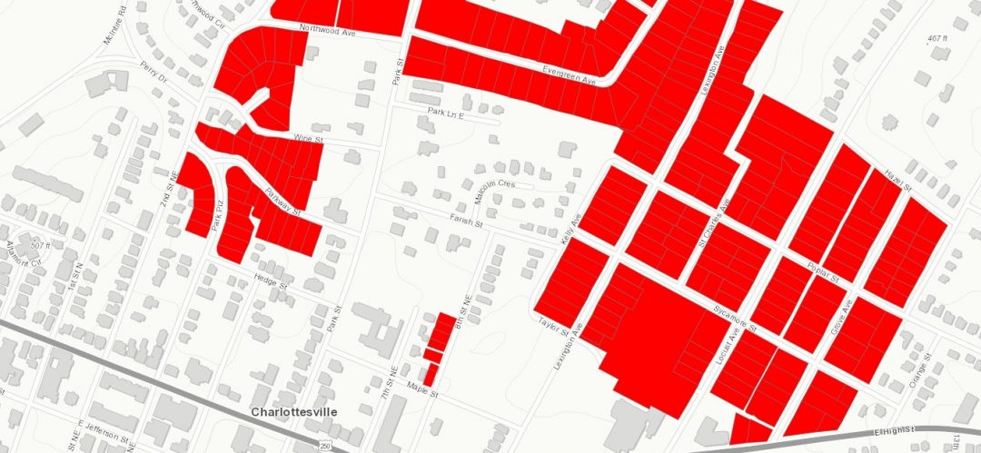
Black Land, Black Schools & Eminent Domain
In 1917, George F. Johnson was six years out of Howard University’s medical school. Three years earlier, the Orange County native had married Peachie Suporah Carr, a native of Albemarle County, who had recently graduated from the Virginia Normal and Industrial Institute (Virginia State University). 1940 Census records Together they lived in the heart of … Continue reading Black Land, Black Schools & Eminent Domain
Mapping Cville Update to City Council
38-MIN VIDEO UPDATE ON MAPPING CVILLE'S BACKGROUND AND PROGRESS: CLICK POST TO WATCH
Mapping: 1903-1933 (VIDEOS)
(1) 1903-1923: 2-MIN VIDEO: CLICK POST TO WATCH ••••• (2) 1923-1933: 2-MIN VIDEO: CLICK POST TO WATCH
4. Belmont: Graves Addition
By Phil Varner The Belmont neighborhood derives its name from the Belle Mont Estate, a 500+ acre plantation on which much of the neighborhood was built. The Belmont Mansion plantation house, now converted to apartments, was likely built around 1820 for John Winn, the postmaster of Charlottesville for many years. Immediately prior to residential development, … Continue reading 4. Belmont: Graves Addition
NEW: Virtual Logging Workshops
Starting this Thursday, August 13, 2020, we'll be hosting a series of regular hour-long virtual logging workshops via Zoom. Each week, the new link will be posted on the right side of the MappingCville.com homepage, above the video tutorial link, as pictured here. At the top of each hour, these sessions will provide a short … Continue reading NEW: Virtual Logging Workshops
3. (1903-1910) East High Street – Little High Street
You have now helped us log nearly 1,000 property records with racist covenants in them! This, in itself, is amazing and fantastic, but it also means that, in addition to mapping them, we now have enough data to begin telling the chronological story of how these racist covenants spread and evolved in Charlottesville and Albemarle … Continue reading 3. (1903-1910) East High Street – Little High Street
